Heslington Archaeology
Most of the archaeological discoveries in Heslington have been made during excavations prior to the expansion of the University to create the east campus . The University supported excavations over a number of years and good evidence was found of occupation on since the end of the Ice Age.
Little archaeological investigation had been undertaken in the village before this major project; a pot with a Roman coin hoard (read more HERE) was found by workmen during construction of the university library, and an early Anglian settlement was discovered by Field Archaeological Services near Siward's How. Victorian gravel extraction near Windmill Lane found Roman amphora, stone coffins containing gypsum burials and glass vessels, and a Neolithic/Bronze Age spear head, amphora and a figurine were found in the village near Hall Park.
The village we know today was well established before the Norman Conquest and is probably an Anglian Settlement. Successive years of fieldwork by landscape archaeology students has identified large areas of medieval ridge and furrow cultivation around the village.
This page of our website was created following our 2023 Festival of Ideas conference Food and Farming in Early Heslington and provides links to many of the presentations given by our expert speakers. We also have links to some of the articles and reports on the discoveries.
Download this booklet - The past beneath our feet: the communities of Heslington East - for a good overview
***********************************************************************************************************************************
Investigations at the new Heslington East Campus
Prior to construction of the new east campus, archaeological investigations were undertaken over a number of years by York Archaeological Trust, On-Site Archaeology, specialist contractors and University staff and students.
The investigations followed a series of evaluations undertaken in accordance with methodologies agreed between the Principal Archaeologist for City of York Council, John Oxley, and the University of York Archaeological Consultant, Dr Patrick Ottaway.
Between the spring of 2010 and the summer of 2011, On-Site Archaeology Ltd led a programme of work in advance of the construction of the new spine road in two fields on the south facing slope of Kimberlow Hill. Further excavations extended to the south of the spine road and within a separate area to the southeast.
Further investigations were undertaken by others around this area and across the new campus site.
The excavations revealed a complex archaeological site ranging from the Mesolithic and Middle Bronze Age to the late Roman 4th century AD, and also into the Anglian period. By the medieval period the site appears to have been utilised exclusively as agricultural land, which had continued until the early 21st century.
Unusual geological conditions gave rise to a series of natural springs along the 20m contour line on the south facing slope of Kimberlow Hill and the water had been managed from at least the early Bronze Age to the late Roman period.
Much of the recorded archaeology comprised ditched enclosures and wells of Romano-British date. These were situated towards the periphery of a much more extensive settlement, which was investigated by the University of York Department of Archaeology Field School.
You can download a report on the investigations by On-Site Archaeology HERE
You can access the full digital archive for Heslington East at the Archaeological Data Service HERE
And we have links to a number of reports in these articles and at the bottom of this page
***************************************************************************************************************************************************************************************************
Food and Farming in Early Heslington
|
The Conference Programme & SpeakersJohn Oxley - Chair: Introduction and welcome
Steve Roskams - Prehistoric into Roman Transitions at Heslington East Jon Kenny – Corresponding transitions beyond Heslington Clare Rainsford - the pastoral economy: a perspective from the animal bones Dave Heslop - the agricultural economy: a perspective from the querns Dave Heslop's script to accompany his presentation Paul Toy – the Song of the Grotti (an Old Norse song of the quern stone grinding slaves). Paul first explained the poem and then sang it beautifully! Malin Holst – Peopling the Heslington landscape: human skeletal analyses. Steve Roskams – Cultural transitions within and beyond the Roman period at Heslington: ceramic perspectives Cecily Spall – Life in Heslington into the post-Roman period John Oxley - Questions and discussion Information about the speakers can be read lower down this webpage We are grateful that our speakers have given permission for their presentations to be made available. Just click on the links above to download a pdf of the powerpoint slides. |
**********************************************************************************************************************************
For a full report on the archaeology and an in-depth analysis and expert interpretation of how this helps build a picture of life below Kimberlow Hill, you can download the full Research Report by Cath Neal and Steve Roskams, published by the Society of Antiquaries; Landscape and Settlement in the Vale of York: Archaeological Investigations at Heslington East 2003-13.
***********************************************************************************************************************************
Location, Location, Location...
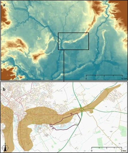
Heslington lies at the centre of the low-lying Vale of York… that has both shaped, and been shaped by, communities living there since the end of the last Ice Age.”(1) “About 14,000 years ago the Vale of York was filled by a glacier moving southwards, producing a large lake of meltwater in the south of the region. When the glacier stopped close to modern-day Escrick it created a distinctive ridge…the Escrick moraine.
As the glacier retreated to the north, another moraine was deposited close to the location of modern York. This produced a second ridge of higher land, forming a routeway across the Vale of York during the prehistoric period. Kimberlow Hill, on the Heslington East site, is part of this east-west York moraine, comprising sands, clays and gravels.
The interface between these different deposits generated contact springs along the hillside…creating a mosaid of habitats, attracting wildlife as well as people and their domestic animals.(2)
1.... Roskams and Neal, The Past Beneath our Feet: note 2 (p 4), note 3 (p 23), note 4 (p 5), note 5 (pg8), note 6 (p 10), note 7 (p 7)
2.... Roskams and Neal, Landscape and Settlement in the Vale of York: note 1 (p ix), note 8 (p 36)
****************************************************************************************************************************************************************************************************
The Importance of Water on the Site
By far the most significant local resource to influence human activity on the site is water. This was true of the earliest period in prehistory, and continues up to the most recent landscape development: the 10-hectare lake at the Heslington East campus.
The use of water in the Heslington landscape has varied considerably over time. Mesolithic flints from a pit near a hill-side spring suggest that this spring was first used between 11,500 and 6,000 years ago. Some ‘new stone age’ features have been identified on the site, but seem to be isolated pits. In the period from 4,300 years ago, a change in technology from stone to metal heralded what we describe as the Bronze Age. Features at Heslington East suggest more concerted water management of the spring line starting around 3,500 years ago.
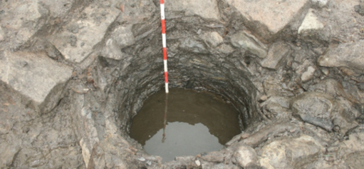
Across the site during the Iron Age and Roman periods, the water source was managed in various ways. Some wells dug during the Iron Age appear to have been unlined and perhaps provided access to water for only a limited time.
The photograph on the right shows a wickerwork lined well with a capping of re-used masonry. Image On-Site Archaeology.
Additionally “a series of field systems, enclosures and roundhouses can be dated to the Iron Age and this evidence inspired the reconstruction drawing by Ed Clark which shows a view over Kimberlow Hill during the late IronAge/Early Roman period. This image is so evocative we have used at the top of this page.
During the Roman period, the flow of water from the springs was managed through ditch systems and wattle-lined channels.
A number of cobble-lined and wattle-lined wells were constructed and the central landscape saw significant development throughout the Roman period.
***************************************************************************************************************************************************************************************************
By far the most significant local resource to influence human activity on the site is water. This was true of the earliest period in prehistory, and continues up to the most recent landscape development: the 10-hectare lake at the Heslington East campus.
The use of water in the Heslington landscape has varied considerably over time. Mesolithic flints from a pit near a hill-side spring suggest that this spring was first used between 11,500 and 6,000 years ago. Some ‘new stone age’ features have been identified on the site, but seem to be isolated pits. In the period from 4,300 years ago, a change in technology from stone to metal heralded what we describe as the Bronze Age. Features at Heslington East suggest more concerted water management of the spring line starting around 3,500 years ago.
Across the site during the Iron Age and Roman periods, the water source was managed in various ways. Some wells dug during the Iron Age appear to have been unlined and perhaps provided access to water for only a limited time.
The photograph on the right shows a wickerwork lined well with a capping of re-used masonry. Image On-Site Archaeology.
Additionally “a series of field systems, enclosures and roundhouses can be dated to the Iron Age and this evidence inspired the reconstruction drawing by Ed Clark which shows a view over Kimberlow Hill during the late IronAge/Early Roman period. This image is so evocative we have used at the top of this page.
During the Roman period, the flow of water from the springs was managed through ditch systems and wattle-lined channels.
A number of cobble-lined and wattle-lined wells were constructed and the central landscape saw significant development throughout the Roman period.
***************************************************************************************************************************************************************************************************
OUR CHAIR FOR THE CONFERENCE
JOHN OXLEY MBE FSA, was the first City Archaeologist for City of York Council, a post he held from 1989 to retiring in 2019. He studied at the University of Liverpool and worked in Southampton for seven years before coming to York. At York, he developed and put into practice an effective model for the management of archaeology in perhaps the most important and sensitive historic city in the UK. He promoted the development of Community Archaeology in York. He initiated two of the largest archaeological research projects ever carried out in York: the Hungate Project and the University of York Campus 3 project.
He was responsible for repair and restoration works on York City Walls and the general strategic framework for managing the walls. His research interests include heritage management, urbanism in Roman and post-Roman Europe, and world heritage studies. He was elected a Fellow of the Society of Antiquaries of London in 2008. He was awarded an MBE in 2021 for services to heritage.
John has retired from York and is now Co-Director of Big Ideas By The Sea, Scarborough’s Festival of Ideas, and of the Scarborough Big Dig, a unique community archaeology project in Scarborough Old Town. He is also a member of the York World Heritage Steering Group which applied successfully to have York placed on the UK Tentative List of World Heritage Sites in 2023.
|
OUR SPEAKERS
STEVE ROSKAMS joined the staff of the University of York in 1983 after spending ten years in rescue archaeology. He directed excavations in Carthage, Tunisia and in London, notably the large excavations at Billingsgate; and has worked on other sites in Algeria and Beirut. Latterly he had concentrated his efforts on investigation of a ‘Dark Age’ site at Mothecombe in southwest England and, closer to home, Iron Age and Roman landscapes and settlement on the Yorkshire Wolds and in York’s immediate hinterland. Steve is interested in all aspects of archaeological fieldwork, both of theory and of practice. The former involves the construction, from a Marxist perspective, of frameworks for understanding landscape change in relation to transitions between the Iron Age and Roman periods, and between the latter and the medieval period. As to practice, this includes the development of excavation methods and analysis to aid the interpretation of complex, deeply-stratified sequences and of extensive shallow sites. Steve has recently completed the important publication of the Heslington East Project: Landscape and Settlement in the Vale of York: Archaeological Investigations at Heslington East, York. DR JON KENNY is an independent community archaeologist specialising in working with communities to understand their historic landscapes. He is a graduate of the University of York and went over the Pennines to obtain his PhD at Lancaster University. After returning to York, he worked at the University before joining York Archaeological Trust as a community archaeologist. He branched out on his own 7 years ago. Abstract of his paper: An Iron Age and Romano British agrarian landscape in the Southern Vale of York. This paper outlines the community work undertaken by community groups in North Duffield and Cawood investigating the landscape around the rivers Ouse and Derwent in the Southern Vale of York, immediately south of Heslington. Drawn by aerial photography to the plethora of Iron Age and Romano British field systems and small settlements in their landscapes these groups have raised funds and undertaken a number of excavations over a 10 year period. The paper will highlight the continuity observed in settlement development through the Iron Age into the Romano British and also suggest a possible reason for the lack of Villas appearing in the landscape between the Ouse and Derwent CLARE RAINSFORD MA MSc PhD is a freelance zooarchaeologist working in York, UK, with a particular interest in ritual uses of animals in the Roman and Anglo-Saxon periods in Britain. She was an Archaeology and Anthropology undergraduate at the University of Cambridge and applied to the University of York for her MSc because it “runs one of the only dedicated Zooarchaeology Masters’ courses in the country.” She has worked for York Archaeological Trust on the faunal remains from the large-scale multi-period Hungate excavations in York. Clare has been zooarchaeologist for the Teffont Archaeology Project and PASt Landscapes which have excavated Roman sites including two Late Roman shrines and the Deverill villa. Clare’s PhD explored the role of animals in early Anglo-Saxon mortuary practices in eastern England. |
PAUL TOY studied at the Universities of Manchester, York and Durham. He has worked in bookshops, libraries, archives, and museums - chiefly at the York Minster (Old Palace) Library and for the York Archaeological Trust. He has given papers at various academic conferences, and has lectured for the WEA, for PLACE (York St John), and for a variety of local history groups and organisations. Paul also maintains a (lowkey) theatrical career. He trained at the Webber Douglas Academy and has worked for professional companies and as a paid director for community theatre groups. He is a former Artistic Director of the York Wagon Plays. MALIN HOLST has worked in British archaeology since 1987, including at Sutton Hoo and at the Towton 1461 mass grave. She obtained her MSc in Osteology, Palaeopathology and Funerary Archaeology from Bradford & Sheffield Universities and founded York Osteoarchaeology Ltd in 2003, a company specialising in the osteological analysis of human remains from commercial archaeological excavations. She has lectured in the Department of Archaeology at the University of York since 2003 and is part of a number of research projects, including ‘The melting pot of Eboracum: exploring diversity and identity through skeletal and burial evidence in Roman York’. Malin has a long list of significant publications, involving osteological analyses, biomolecular and funerary research. In 2013 she received the York University Student Union’s ‘Excellence in Teaching and Supervision Awards’ and the Vice-Chancellor’s Teaching Award. Malin is a member of the Chartered Institute for Archaeologists (MCIfA) and a Fellow of the Society of Antiquaries (FSA). CECILY SPALL is a senior field archaeologist with over 25 years of experience in archaeological excavation and project management. Cecily studied Archaeology at the University of York (BSc (Hons) 1994-97) and joined FAS Heritage on graduation going on to study part-time towards her Masters in Heritage Management at the University of Birmingham (2000-2001). She was appointed as co-director of the Tarbat Discovery Programme in 1999 by Professor Martin Carver and Director of FAS Heritage in 2005. Cecily specialises in archaeological excavation and publication including legacy archives and has research interests in the medieval period, most particularly in burial practice and material culture. DAVID HESLOP became involved with the Yorkshire Quern Society in the 1990’s. He has been Tyne & Wear County Archaeologist (1997-2016) and is currently co-director of New Visions Heritage Ltd. He has been the cathedral Archaeologist for New Castle and Carlisle and, recently archaeologist on the major HLF scheme at Cathedral of St Nicholas, Newcastle upon Tyne. Other projects are: The Rome Transformed Project (ROMETRANS) with the Universities of Newcastle and of Florence and, for Historic England, Production of Research Assessment and Agenda for the late Bronze Age and Iron Age periods of the North-east Regional Research Framework. David is a full member of the Chartered Institute for Archaeologists; President of the Society of Antiquaries of Newcastle upon Tyne; and Fellow of the Society of Antiquaries of London. |
The Iron Age Brain
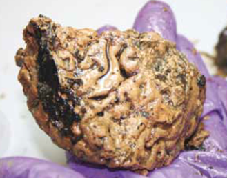
A find of international importance was the human skull containing part of a brain. It was recovered from a water hole on the west of the site in 2008 and has been dated to the Iron Age period, about 2000 years ago.
Analysis of the vertebrae attached to the skull indicates that before deposition the man had been hung and then decapitated.
You can read about a scientific analysis of the brain published by Manchester University HERE
And this issue of Yorkshire Archaeology Today has an article on Britain's Oldest Brain - download it HERE
Photograph: York Archaeological Trust
Roundhouses
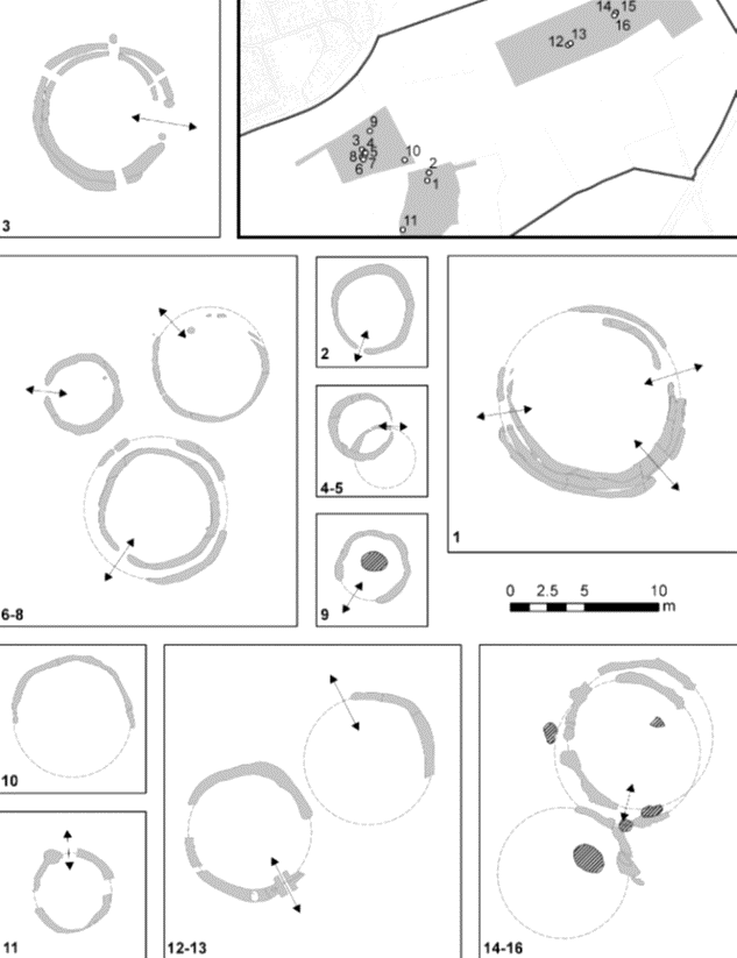
By the Late Iron Age, there is more certain proof of structural development on the site in the form of a number of roughly circular buildings – ‘roundhouses’. Their levels of preservation varied hugely across the site, even to the extent of their actual number being uncertain, but sixteen have been identified and numbered, as shown on the site plan and detailed drawings below by Helen Goodchild. (The arrows indicate the entrances where this has been identified.)
The majority are in line with Iron Age equivalents in the region, and surviving evidence suggested that their superstructure comprised uprights placed in a circle, supporting sloping rafters, with no central member. Most structures were either kept clean during their lifetime or had evidence for internal occupation truncated by later activity, so they are mainly dated from artefacts filling the ring ditches set out around them. But these finds only date final demise, and each roundhouse could have been in use and kept clean for some decades, if not more, before filling up.
Where their internal diameter could be measured or reasonably defined, it averaged between 5m and 6m (also in line with other regional equivalents). When viewed in detail, however, the Heslington structures fell into three groups: those between 3.5m and 4.5m across (six), between 6.7m and 7.7m (six) and between 9m and 10m (four).
This text has been edited from the report by Steve Roskams and Cath Neal
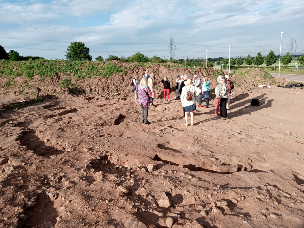
In June 2021, Steve Roskams and Al Oswald of the University of York gave members of Fishergate, Fulford and Heslington Local History Society a tour of their current excavations. Here we are standing inside one of the roundhouses.
Steve Roskams has kindly given us copies of a range of reports about the Heslington East Project.
You can download them by clicking on the title:
A Late Roman Well at Heslington East. York: ritual or routine practices?
Project summary display boards
The Landscape of Heslington East: An evaluation of approaches used to assess the Historic Landscape
Exceptional preservation of a prehistoric human brain from Heslington,
Yorkshire, UK
The Limitation of Water Flow and the Limitations of Postmodernism
The Post-excavation Analysis and Archiving of Outputs from Complex, Multi-period Landscape Investigations: the example of Heslington East
Community Engagement Report
Authority and Community: Reflections on Archaeological Practice at Heslington East
Assessing, Teaching, Learning Archaeological Skills (ATLAS) Narrative Report
You can access the full digital archive for Heslington East at the Archaeological Data Service HERE