Use the drop-down menu at the top of the screen to find pages on the new and old St Oswald's churches, the Battle of Fulford and archaeology at the Germany Beck housing development and more about Fulford.
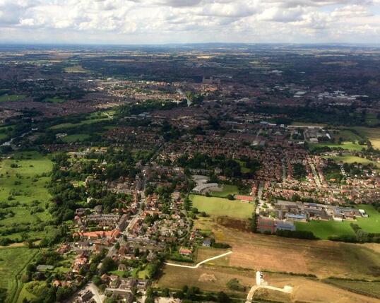 Aerial View of Fulford looking north from Fordlands Rd. The open fields on the right are now the Germany Beck housing estate. Image: Hayden Lewis for York Press
A Brief History of Fulford:
A journey through the village along the A19 to Fishergate
The history of York is sometimes said to be the history of England and in the same way, the history of Fulford could also be seen as echoing the history of York.
The village runs along a ridge of the same glacial deposits that raised the ground above flood level and made York a good place for the Romans to build their northern headquarters.
Hunter-gatherers left their flint arow heads near the river Ouse and stone age tools have been found at Lincroft, a mile or so south of the A64. The A19 is now recognised as a Roman road, and Roman burials were found during construction of the A64 junction and near the old church of St Oswald.
Roman building materials and artifacts have also been found at the primary school and the new Germany Beck housing estate, and near the old church.
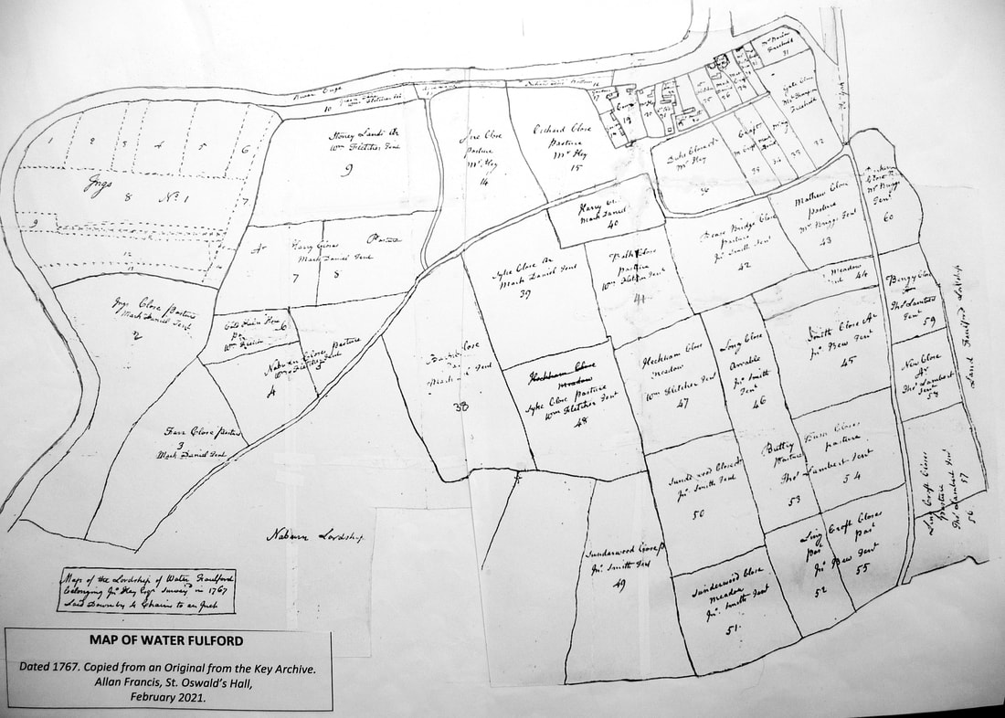
As you approach the village from the south, passing the Designer Outlet (built on the site of an Edwardian asylum and hospital) you are in the lost village of Water Fulford. This was a separate Manor to the main village of Gate Fulford, and an 1767 map appears to show a gate on the A19 near Landing Lane, where the two villages meet.
The villages were united in 1763, when John Key inherited both the Manors. The location of the manor House for Gate Fulford has not been firmly identified, but it may have been one of the large houses overlooking the Ings in Fenwicks Lane, or Fulford Park House, opposite Heslington Lane.
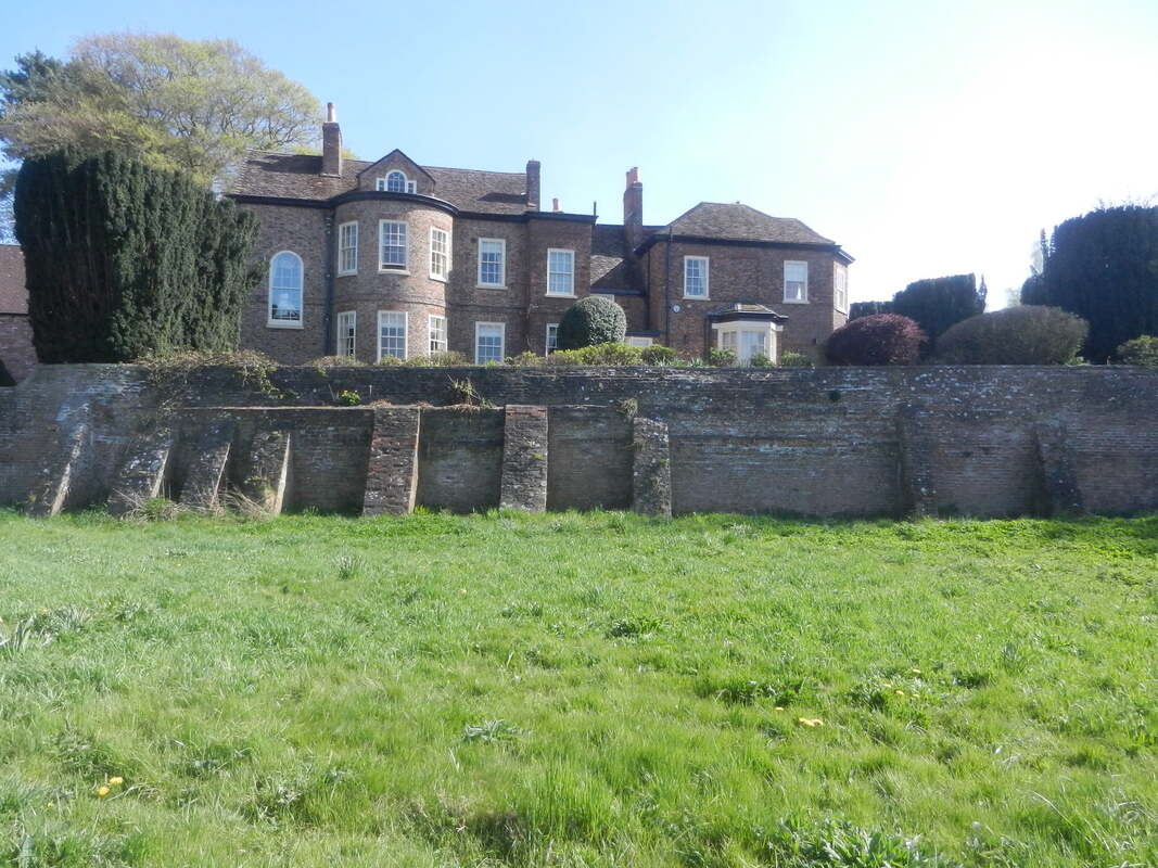
Water Fulford Hall has medieval elements hidden by later building works. It stands in a prominent position overlooking a sharp bend in the river Ouse where there used to be a village wharf. The Hall is reached by Landing Lane, which also leads to the low lying area between the village and the river known as the Ings. This was used for gathering a hay crop and summer grazing of the villagers’ cattle. (read more about the Ings, Germany Beck and the village wharf HERE)
(hold your mouse over the images to read the caption)
A journey through the village along the A19 to Fishergate
The history of York is sometimes said to be the history of England and in the same way, the history of Fulford could also be seen as echoing the history of York.
The village runs along a ridge of the same glacial deposits that raised the ground above flood level and made York a good place for the Romans to build their northern headquarters.
Hunter-gatherers left their flint arow heads near the river Ouse and stone age tools have been found at Lincroft, a mile or so south of the A64. The A19 is now recognised as a Roman road, and Roman burials were found during construction of the A64 junction and near the old church of St Oswald.
Roman building materials and artifacts have also been found at the primary school and the new Germany Beck housing estate, and near the old church.
As you approach the village from the south, passing the Designer Outlet (built on the site of an Edwardian asylum and hospital) you are in the lost village of Water Fulford. This was a separate Manor to the main village of Gate Fulford, and an 1767 map appears to show a gate on the A19 near Landing Lane, where the two villages meet.
The villages were united in 1763, when John Key inherited both the Manors. The location of the manor House for Gate Fulford has not been firmly identified, but it may have been one of the large houses overlooking the Ings in Fenwicks Lane, or Fulford Park House, opposite Heslington Lane.
Water Fulford Hall has medieval elements hidden by later building works. It stands in a prominent position overlooking a sharp bend in the river Ouse where there used to be a village wharf. The Hall is reached by Landing Lane, which also leads to the low lying area between the village and the river known as the Ings. This was used for gathering a hay crop and summer grazing of the villagers’ cattle. (read more about the Ings, Germany Beck and the village wharf HERE)
(hold your mouse over the images to read the caption)
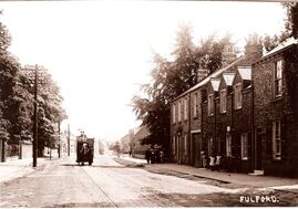
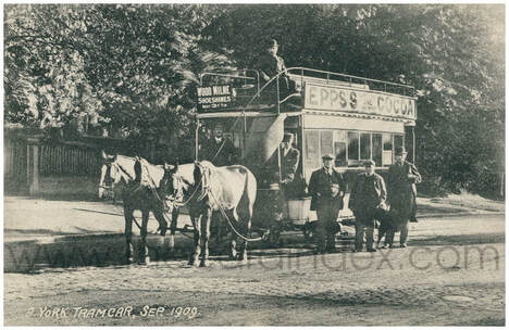 Tram at the south end of the village. Image Cardindex
Fulford is famous for the battle in September 1066, when Harald Hardrada, king of Norway and Tostig Godwinson, exiled earl of Northumberland, sailed up the Ouse and defeated a hastily assembled army of York men led by Morcar, the Earl of Northumberland. The location of the battle has never been firmly identified, but is generally believed to have been around the area of Germany Beck, which would form a natural barrier between the two armies. (read more about the Battle of Fulford HERE)
A new road junction just north of Germany Beck, gives access to Fordlands Road, formally Dam Lands Lane, which leads south east past the cemetery into an area of flat farmland known as the Tilmire. This was once fenland, but drainage works begun by St Mary’s Abbey in the 14th century have turned it into productive farmland. Many field boundaries and ditches laid out in the 18th century Enclosures can still be seen across this open landscape.
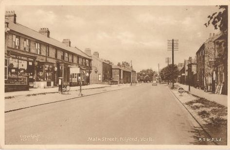
The verges of the A19 widen through the village into Main Street, with a wide variety of houses and even a few modern flats overlooking grass verges. Some of the houses are 18th century and a few have older timber framed structures hidden within a later building.
The layout of the medieval linear village can still be seen in the long narrow house-plots which stretch back from Main Street to back lanes. Most of these ‘toft and croft’ plots have been infilled with more houses, but there are still some narrow footpaths leading from Main Street to the back lanes.
Although close to the city, Fulford retains many of the attributes of a rural village. Until relatively recently, there were blacksmiths, builders, butchers, dairy, baker, a post office, general store, garage, and makers of the Fulford Biscuit. One of the three pubs is closing soon, but there were once as many as six. (you can read about some of the buildings and shops of Main Street lower down this page)
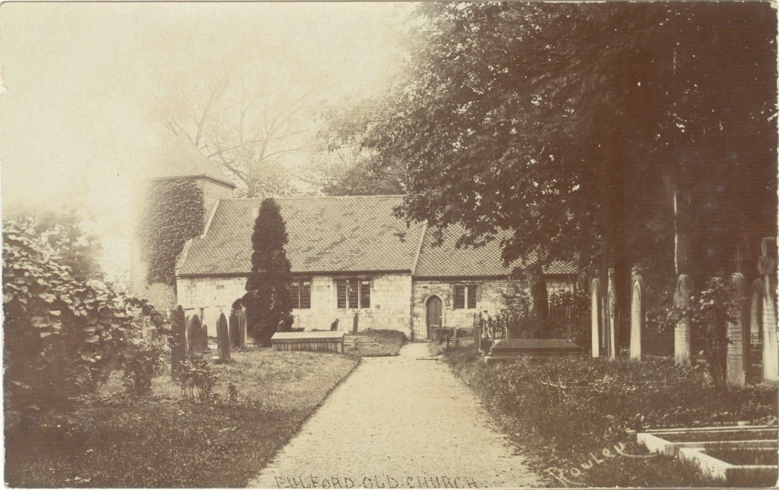
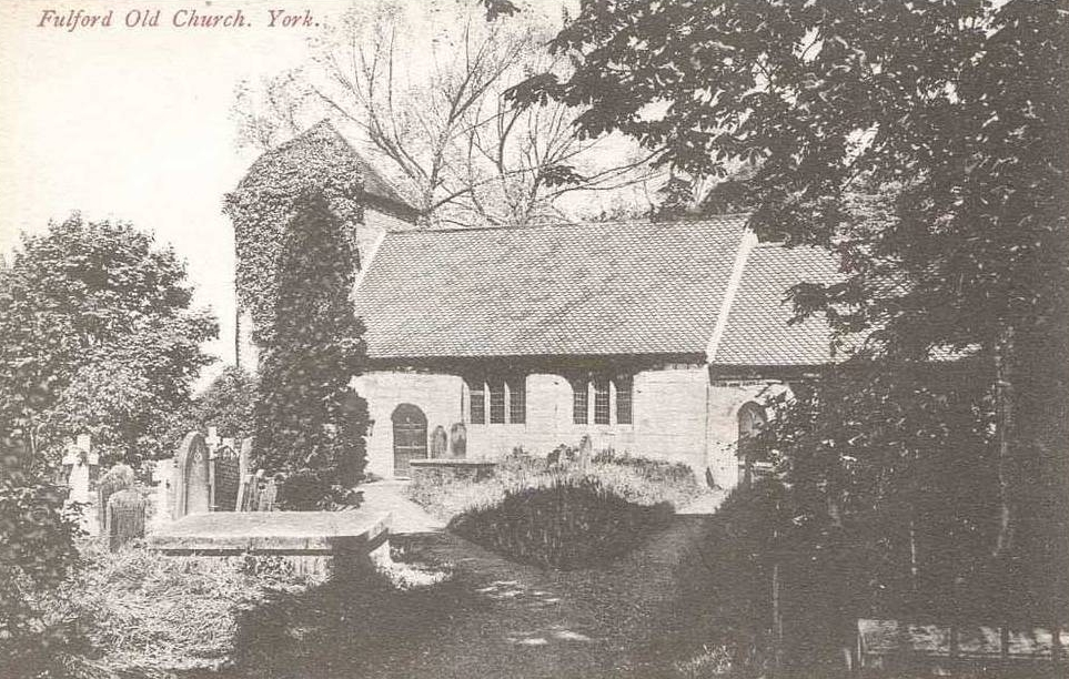
Heslington Lane runs east from the north end of Main Street and connects the two villages with Hull Road. The unprepossessing pale brick house on the corner was once the home of Captain Anthony Lefroy, Barrack Master and possible love interest of Jane Austen. (read more HERE) St Oswald's church is a little further north, and almost opposite are the Sir John Hunt Almshouses. (read more HERE) Then St Oswald’s Road leads to the original church, now a private house, near a probable early crossing point of the river Ouse.
It is unusual for a village church not to be within the main area of habitation, suggesting that it may have origins pre-dating the village. Investigations in the 1980s discovered a fragment of a 9-10th century stone cross, and the foundations of an earlier church were also found. Until the late 19th century there was a well where the lych gate is today, and it has been suggested that the cross and early church were erected to Christianise a holy well that was used to bless a safe passage across the river. (you can read more about the history of the old church HERE)
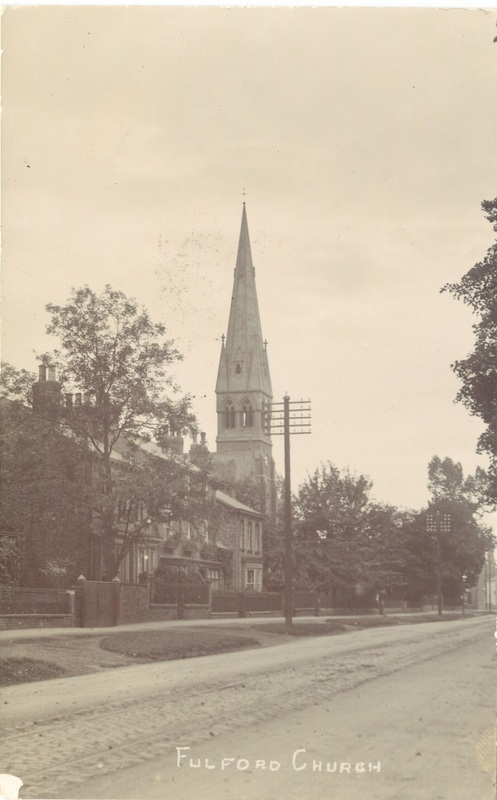
By the mid-19th century, the old church had become too small for the growing population and a new church was built at the north end of Main Street, designed by J P Prichett. Sadly, the original William Morris stained glass was lost in a disastrous fire just eleven years after consecration. The 24m tall steeple was weakened by the fire and replaced with the present clock tower in 1924. (you can read more about the new church HERE)
Towards Fishergate, a cavalry barracks was built in 1795. The military establishment was enlarged 100 years later when an infantry barracks was built, with an ordnance depot and military hospital on the west side of Fulford Road.
The cavalry barracks has mostly been demolished but the infantry buildings survive, including the imposing brick Keep next to the main gate. (you can read more about the barracks in Fulford HERE)
The move of the Northern Command headquarters from Manchester to Tower House in Fishergate, prompted the Corporation to build a horse-drawn tram line to Fulford in 1880, with an office at the Plough Inn. The line was electrified in 1911 and a depot for the trams was built on the site of modern Aldi, with houses built nearby for some of the staff.
Opposite the Keep is the base and pedestal of a 15th century stone cross, erected to solve a dispute over grazing rights between villagers and St Mary’s Abbey. A small stream once crossed the road near this point and it was here in 1542, that the city gentry and Corporation presented gold to Henry VIII and begged forgiveness for their role in the rebellion known as the Pilgrimage of Grace. (you can read more about Henry VIII Royal Progress to York HERE)
Despite the relentless flow of traffic, modern Fulford still has a sense of being separate from the city, with a community café in the church hall, an integrated library and primary school, regular events in the Community Hall and an annual Summer Show. This local history society holds most of its meetings in the church hall.
There is much more information on other pages of this website, and you can download an extract from the Fulford pages of the Victoria County History HERE.
A very rare gold shilling dating from AD c.620-650 has been found in Fulford. For more details click HERE
A new road junction just north of Germany Beck, gives access to Fordlands Road, formally Dam Lands Lane, which leads south east past the cemetery into an area of flat farmland known as the Tilmire. This was once fenland, but drainage works begun by St Mary’s Abbey in the 14th century have turned it into productive farmland. Many field boundaries and ditches laid out in the 18th century Enclosures can still be seen across this open landscape.
The verges of the A19 widen through the village into Main Street, with a wide variety of houses and even a few modern flats overlooking grass verges. Some of the houses are 18th century and a few have older timber framed structures hidden within a later building.
The layout of the medieval linear village can still be seen in the long narrow house-plots which stretch back from Main Street to back lanes. Most of these ‘toft and croft’ plots have been infilled with more houses, but there are still some narrow footpaths leading from Main Street to the back lanes.
Although close to the city, Fulford retains many of the attributes of a rural village. Until relatively recently, there were blacksmiths, builders, butchers, dairy, baker, a post office, general store, garage, and makers of the Fulford Biscuit. One of the three pubs is closing soon, but there were once as many as six. (you can read about some of the buildings and shops of Main Street lower down this page)
Heslington Lane runs east from the north end of Main Street and connects the two villages with Hull Road. The unprepossessing pale brick house on the corner was once the home of Captain Anthony Lefroy, Barrack Master and possible love interest of Jane Austen. (read more HERE) St Oswald's church is a little further north, and almost opposite are the Sir John Hunt Almshouses. (read more HERE) Then St Oswald’s Road leads to the original church, now a private house, near a probable early crossing point of the river Ouse.
It is unusual for a village church not to be within the main area of habitation, suggesting that it may have origins pre-dating the village. Investigations in the 1980s discovered a fragment of a 9-10th century stone cross, and the foundations of an earlier church were also found. Until the late 19th century there was a well where the lych gate is today, and it has been suggested that the cross and early church were erected to Christianise a holy well that was used to bless a safe passage across the river. (you can read more about the history of the old church HERE)
By the mid-19th century, the old church had become too small for the growing population and a new church was built at the north end of Main Street, designed by J P Prichett. Sadly, the original William Morris stained glass was lost in a disastrous fire just eleven years after consecration. The 24m tall steeple was weakened by the fire and replaced with the present clock tower in 1924. (you can read more about the new church HERE)
Towards Fishergate, a cavalry barracks was built in 1795. The military establishment was enlarged 100 years later when an infantry barracks was built, with an ordnance depot and military hospital on the west side of Fulford Road.
The cavalry barracks has mostly been demolished but the infantry buildings survive, including the imposing brick Keep next to the main gate. (you can read more about the barracks in Fulford HERE)
The move of the Northern Command headquarters from Manchester to Tower House in Fishergate, prompted the Corporation to build a horse-drawn tram line to Fulford in 1880, with an office at the Plough Inn. The line was electrified in 1911 and a depot for the trams was built on the site of modern Aldi, with houses built nearby for some of the staff.
Opposite the Keep is the base and pedestal of a 15th century stone cross, erected to solve a dispute over grazing rights between villagers and St Mary’s Abbey. A small stream once crossed the road near this point and it was here in 1542, that the city gentry and Corporation presented gold to Henry VIII and begged forgiveness for their role in the rebellion known as the Pilgrimage of Grace. (you can read more about Henry VIII Royal Progress to York HERE)
Despite the relentless flow of traffic, modern Fulford still has a sense of being separate from the city, with a community café in the church hall, an integrated library and primary school, regular events in the Community Hall and an annual Summer Show. This local history society holds most of its meetings in the church hall.
There is much more information on other pages of this website, and you can download an extract from the Fulford pages of the Victoria County History HERE.
A very rare gold shilling dating from AD c.620-650 has been found in Fulford. For more details click HERE
|
A pictorial tour of Fulford Main StreetOver the last few years, committee members Judy Nicholson and Barbara King have been working very hard finding out all the historical background to the houses in Fulford.
For a quick tour of some of the highlights, you can download a brief summary to investigate at your leisure HERE |
Main Street Walking Trail
In April 2017 we published a new guide to some of the many interesting buildings along Main Street Fulford.
To download a copy of one side of the trail click HERE and again HERE for the other side.
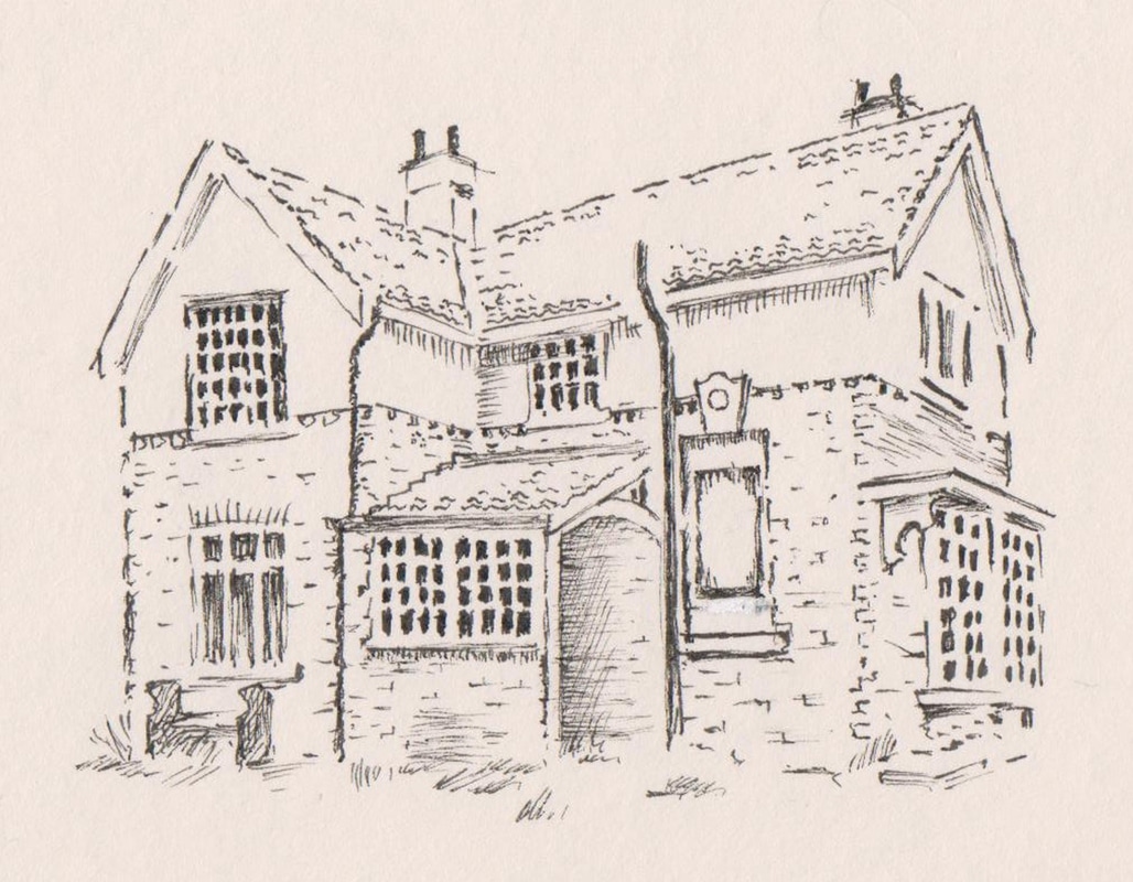
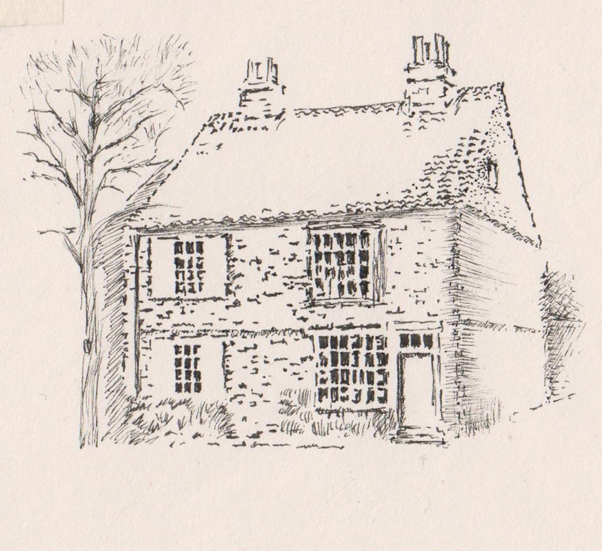
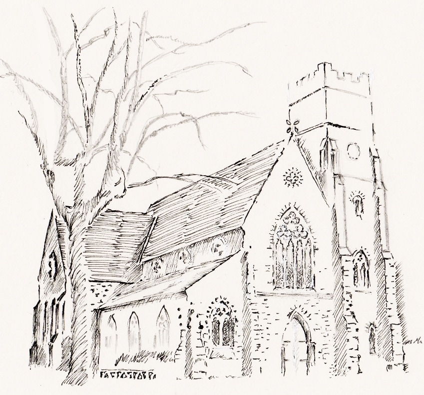
The trail is illustrated with delicate drawings by the lovely late local artist Martin Lomas, including these, below:
In April 2017 we published a new guide to some of the many interesting buildings along Main Street Fulford.
To download a copy of one side of the trail click HERE and again HERE for the other side.
The trail is illustrated with delicate drawings by the lovely late local artist Martin Lomas, including these, below:
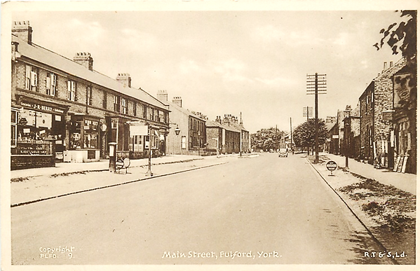 Main Street, Fulford c1965. Image: Private Collection
Fulford's Lost Shops
In September 2018, Barbara King delighted a large and attentive audience with her illustrated talk on Fulford's Lost Shops, and it's surprising how many there were! With the help of Judy Nicholson, Barbara had spoken to many local people and consulted census records, newspaper archives and business websites, to discover that many of the houses along Main Street had once been shops. She also found that some had remained as shops but changed what was sold over the decades as the owners came and went and also as consumer fashions changed or the economics of trading waxed and waned.
Barbara painted a picture of a suburb of York which enjoyed the benefits of its proximity to the city, including a regular tram link, but was also semi-self sufficient in its retailers, so most things needed for everyday life could be obtained locally.
As so often happens in our friendly meetings, the audience also contributed their memories, including some who had owned or worked in the shops and some of their stories were very amusing too.
Barbara began with a summary history of the shops, which I include here:
As early as 1822 the village boasted...
BAKERS Hessel. Thomas Hoyle. Mary Leng. John
BLACKSMITHS Hick. William Marshall. George
FARMERS Cartwright. John Eshelby. Ralph Handley. William Parrott. George Wilkinson. George
SHOEMAKERS Dixon. Thomas Thompson. Richard
WHEELWRIGHTS Hick. Joseph Hick. William
Other Trades
Victualler – The Board Halliday. William
Victualler – The Saddle Johnson. Richard
Victualler – The Plough Tomlinson, Sarah Victualler – The Bay Horse Wilkinson. Mrs
Victualler – Light Horseman Peckitt. James
Tailor Ledberry. William
Butcher Leaf. William
Shopkeeper Nicholson. Thomas
School Master Pearson. Thomas
Coal Dealer Smithson, Robert
Corn Miller Strickland. William
The earliest shop I have found in Fulford Main Street is listed on the 1841 Census as Thomas Dickinson’s, shoemaker of 101 Main Street, followed on by Ann Shaw, a niece of the Dickson family.
Robert Medd on the 1861 Census is shown as a cow keeper and shop keeper in the area close to Medd’s Lane.
1868 Leng’s Biscuit Bakers opened at 77 Main Street.
The first Post Office opened in the village at 18 Main Street around the late 1880’s although the premises in the 1860’s, 70’s and 80’s had been a Bookmakers, Grocers and Shoemaker’s Shop. Various members of the Hall family had been responsible for the various businesses.
Harrison’s Taxis were well established in the late 1800’s having moved from Naburn Lane into Main Street by the 1891 Census.
1905 saw the start of the Duffield empire with Harry Duffield’s cycle shop at his home at 24 Main Street.
Britton’s Dairy began in 1920.
The purpose-built row of shops at the end of Prospect Terrace was built in 1904 and shopping in Main Street began to flourish.
Other household trades and industries, listed in the earlier 1800’s Census’s, which potentially could have been classed as “shops” included:
Building trades, joiners, glazier, blacksmiths, saddlers and cordwainers (shoemakers belonging to a Guild), butcher, market gardeners and nursery men, tailors, knitters, dressmakers and collar makers, laundry workers and char-women.
Small shops were established in the 18th and 19th century in many remote places where transport was limited and a single shop was sufficient to service the needs of the community, but the 1970’s saw the death of the village Grocery Shop. Village shops today tend to be used by firms offering specialised goods and services, rather than food shopping.
The first full-scale supermarket in Britain was opened by the London Co-Operative Society, in Manor Park, on January 12 1948. Sainsbury’s in 1950 and Tesco in 1954. I think that many of our older residents miss The Premier Store (our last small convenience store in Main Street), but for those more able to get around we do have a Co-op, Aldi, Iceland and Sainsbury’s just a short bus ride up Fulford Road.
You can download a copy of Barbara's talk by clicking HERE but please note that the images are Barbara's copyright and must not be used without permission. The slides with images are followed by slides with Barbara's notes, which add lots of interesting details.
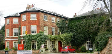
We recently held a meeting at the Pavilion Hotel, where around 60 people came to hear our busy members, Judy Nicholson and Barbara King, give a talk about the history of the building (originally an 18th century farmhouse) and the illustrious families who have lived there.
We are grateful to the Pavilion Hotel for generously providing the meeting room and refreshments to everyone.
The event was a great success and by popular demand, Judy has written a summary which can be downloaded HERE.
We are grateful to the Pavilion Hotel for generously providing the meeting room and refreshments to everyone.
The event was a great success and by popular demand, Judy has written a summary which can be downloaded HERE.
Geophysical Investigations at the Sir John Hunt Memorial Cottage Homes
In July 2015, some 30 FFH members and others undertook an investigation of the grassed areas surrounding the alms houses and other buildings of the Cottage Homes. The almshouses are situated at the north end of the village on Fulford Road, and running west along St Oswald's Road.
The event came about following a suggestion by a student archaeologist, Paul Dudrin, that the group may like to undertake a geophysical survey somewhere in the FFH area. This site was selected because it was close to a recent archaeological investigation in the Connaught Court Masonic Nursing Home, where evidence had recently been found of Roman occupation, including building materials and an Augustan coin, along with mediaeval ridge and furrow. Another reason for choosing the site was that old maps showed it had not been built on.
The investigations found the medieval ridge and furrow continuing from the adjacent Connaught Court area and also some indications of a large bank and ditch near that site's Roman finds. It was also interesting that there was no suggestion of a possible Roman Road running close to and parallel with Fulford Road.
The report on the investigations may be found HERE.
Gate and Water Fulford from 1881-1882 York directory.
A transcript of the residents, both private and commercial in Fulford Parish with a description of the parish in 1881.
Some photos of Fulford Village